Frequently Asked Questions
PERMITS AND INSPECTIONS ARE REQUIRED FOR THE FOLLOWING:
- New Detached Buildings (Residential and Non-Residential) greater than 120 square feet*
- Tenant Improvements
- Solar Installation
- Patio Covers (Solid and Lattice)
- Enclosed Patios
- Electric Charging Station
- Additions and Alterations
- Pools and Spas
- Sheds and other Detached Accessory Structures greater than 120 square feet
- Carports, Garages and Barns
- Fences over 6 ft. in height
- Retaining Walls over 3 ft. in height
- Electrical, Plumbing, Mechanical and Structural Repairs
- Re-roofing (Residential and Non-Residential)
- Temporary structures such as a modular unit, recreational vehicle/trailer.
- Onsite Grading
- Demolition
- Erosion Control
- Signs
- Other types of construction activities, not listed here, may require a permit. All building setbacks must be maintained, whether a building requires a permit or not. Please contact a representative of the Building and Safety Division at (909) 387-8311 or (760) 995-8140 (desert area) for any questions or to verify whether a permit will be required for your project.
*Per County Development Code section 84.01.020(b), An accessory structure or use shall always exist in conjunction with, and never without, a legally established primary structure or primary use that has the same common owner. Where the primary use is a residence, it shall not be enclosed within an accessory structure. Where the primary use has not yet been established, an accessory structure may only be built subject to the issuance of a Temporary Use Permit in compliance with Chapter 84.25 (Temporary Structures and Uses).
Property Owners, State of California Licensed Contractors, or Agent for property owner/ contractor may pull a permit with the following paperwork. Complete paperwork must be current each time a permit is pulled.
Property Owners
- Proof of identification (Driver’s License, State Issued ID card, Alien Registration Card or Passport – Photo ID’s only).
- Proof of ownership if there has been a recent of transfer of ownership (Grant Deed, Property Tax Statement or closing statement from Escrow).
- Notice to Property Owner Form. The property owner signature must be notarized if owner is not present at time of building permit issuance.
- Agents of residential property owners will also need to provide a notarized Authorization of Agent to Act on Property Owner’s Behalf.
- If the property is owned by a Trust, you will need to provide a copy of the trust paperwork showing the trustee or executor.
- If the property is owned by a Corporation, LLC or Partnership you will need to provide a copy of the paperwork verifying the President, Vice-President, CEO, partner, or managing member.
Contractors
- Proof of Identification (Driver’s License, State Issued ID card, Alien Registration Card or Passport – Photo ID’s only)
- Proof of current State of California Contractor’s License & classification (pocket card)
- Agents signing on behalf of License Contractor will also need one the following paperwork:
-
- Letter of Authorization on the Contractor’s letterhead authorizing a person (not a business) to pull the building permit.
- Notarized letter authorizing a person (not a business) to pull the building permit.
-
Note: A tenant of a building cannot pull a permit unless they are an agent for either the Property Owner or Contractor.
120 square feet. Provided that it is a one-story detached tool, storage sheds, playhouses and similar uses if do not contain utilities and are within the minimum setbacks and are less than 14 feet in height.
Permits become expired and invalid if the work is not commenced within 12 months after its issuance. Permits also expire if the work authorized on the site by the permit is suspended or abandoned for a period of 12 months.
The building official is authorized to grant, in writing, a 180-day extension. The extension shall be requested in writing and justifiable cause demonstrated.
Applications for which no permit is issued within 180 days from date of application shall be void or withdrawn.
It is recommended that these documents be kept as permanent record of the work performed. These items may be needed in the future for validation during a real estate transaction or insurance appraisal. All job cards are now electronic.
It is required that the County approved plans be on-site at all times during the construction process and available for the building Inspector. Also, an adult should be on-site during the inspection. All job cards are now electronic.
Inspectors are available in our offices from 8:00 to 8:30 a.m. to discuss inspection issues or to request an inspection window. They can be reached by phone or in person during these times.
A Virtual Inspection (VI) is an inspection performed by utilizing a smartphone or tablet. The major benefit of utilizing VI is the ability to schedule a precise inspection time, thus eliminating the 2-4 hours of wait time.
For more information on Virtual Inspections please visit the following website:
Inspections can be scheduled by downloading the EZ Inspect App on your smart phone, at Accela Citizen Access (sbcounty.gov), or by phone. CLICK HERE for more information. Please have your permit number available for scheduling.
Inspection requests received by 4:00 pm will be scheduled for the following work day. When the schedule is full for the next day, the inspection will be scheduled for the next available day. Note: Due to the remote nature and low volume of requests, some areas of the County have limited inspections available during the week. Please click here to verify when inspections are available in your area.
For remote locations please consider using a virtual Virtual Inspections – EZ Inspect App (sbcounty.gov) or a self-inspection Self Inspections – EZ Inspect App (sbcounty.gov).
In general, an inspection will be required prior to covering up or concealing any completed work.
The following is a list of typical construction inspections and the general sequence in which they should occur. All required erosion control measures shall be in place, inspected and approved prior to commencing any building construction activity.
- UNDERGROUND/UNDER SLAB PLUMBING: Prior to any footing or foundation inspection, rough underground waste plumbing to be in place and a water test provided (cap all ends and openings and provide a 10 foot head of water).
Measurements from building forms to property lines will be verified at this time to ensure the approved building setbacks are maintained. Setback certification (if required) shall be provided to the inspector.
- FOUNDATION INSPECTION, CONCRETE SLAB GRADE OR UNDER-FLOOR: To be made after all ground plumbing has been approved and backfilled. All required reinforcing bars, hardware, and holdowns are in place. This inspection must be performed and approved before placement of concrete slab or floor sheathing.
- ROOF SHEATHING AND SHEAR WALL INSPECTION: To be made after all roof sheathing is in place and nailed as per the approved plans, but before any roofing materials are applied or loaded on the roof. All required plywood shear panels on exterior walls must also be nailed per the approved plans and inspected before being covered by exterior finish materials. Roof Framing and Truss systems will also be checked for compliance with the approved plans.
- COMBO INSPECTION (ROUGH ELECTRICAL, MECHANICAL, PLUMBING, & FRAMING INSPECTIONS): To be made after all framing and roofing is completed (tile roofing need not be complete if the roof has been made substantially weather tight, but tile must be loaded on roof). All rough plumbing (including fire sprinkler piping, if required), mechanical and electrical installations must be in place. Water supply piping (hot and cold) shall be under pressure and any second story shower and/or tubs shall be filled with water along with all drain, waste and vent piping below the overflow level of the tubs. Shower pans are built/installed and filled with water for testing. Fireplaces must be installed. Stucco paper & lath must be in place and nailed as per approved plans. Window frames and exterior door frames must be in place and properly flashed.
Note: Fire Department rough inspection must be approved prior to Building & Safety’s Combo inspection.
- INSULATION INSPECTION: To be made after all required insulation is in place, openings caulked and required sealing done. Vapor barrier on walls and ceiling to be in place in climate zones 14 & 16 (Mountain & Desert regions).
- DRYWALL INSPECTION: To be made after all drywall (or interior lath) and all attachments are fastened in place per the approved plans. To be approved before scratch-coat is applied and before any drywall mud is applied.
- SEWAGE DISPOSAL & WATER SERVICE FROM METER TO HOUSE INSPECTION: To be made after trenches are dug, piping is in place and the appropriate test is applied. The general contractor is responsible for supplying the inspector with an accurate as-built drawing showing locations of these lines. This inspection must be done before any piping is covered or trenches back filled. Septic tank and disposal fields (leach field or seepage pits) must be complete and exposed for inspection. Septic tanks are to be filled with water for leak testing.
- GAS LINE AIR TEST: Indoor, Outdoor, and Underground gas lines must be under an air test using a maximum 15lb gauge and not lose any pressure for 15 minutes. This inspection can be completed after cabinets and molding are installed in the building.
- FINAL INSPECTION: To be made when structure is ready for occupancy. This shall include proper lot drainage, post construction erosion control measures, permanent address posted, all plumbing fixtures connected and operable, all electrical fixtures and devices in place and electrically connected, insulation certificate posted, structure clean of debris or stored materials, wall finishes complete per approved plans, HERS Rater report on-site, etc.
Please be advised that all final inspections must be cleared (in writing) before utilities are released and a Certificate of Occupancy is issued. This includes final clearance from not only the Building & Safety Division but also Planning, Land Development, Public Works Roads, Fire Department and Solid Waste Construction Waste Management Plan, (CWMP) Clearance. All outstanding fees owed to these departments must be paid prior to approving a final inspection and granting a Certificate of Occupancy.
Note: The general contractor/owner-builder or his duly authorized representative is responsible for verifying that all work is complete before requesting an inspection. This authorized representative shall also be responsible for walking with the inspector on all inspections and for coordinating all of his/her subcontractor duties relevant to correction items cited by the inspector. Re-inspections will be made as requested after all corrections have been made.
Please provide a sufficient temporary address so that the inspector can easily identify your property.
San Bernardino County Fire Hazard Abatement Process Summary
• Initial property surveys are conducted in unincorporated areas of San Bernardino County as well as
contract cities.
• A Notice and Order to Abate is issued to properties where fire hazards have been identified. There
is a 30-day timeframe to comply.
• A property owner may appeal the Notice and Order to Abate within the 30-day compliance
timeframe. There is a $100.00 filing fee to appeal in which is refunded only if the appeal is
successful.
• A second survey is conducted after the Notice and Order to Abate compliance due date.
• Non-compliant properties are issued a Notice and Intent to Abate notice following the second
property survey. Non-compliant properties will also receive a $100.00 administrative citation and an invoice for administrative fees related to the second inspection in a separate letter. The
property owner has an additional 10 days from the Notice and Intent to Abate mailing date to
contact our office and submit photographic evidence of completed abatement.
• The County will initiate action to abate fire hazards on the remaining non-compliant parcels after
the 10-day additional grace period.
• An abatement warrant will be obtained if abatement is required on parcels with structures. The
administrative cost of $298.00 for warrant procurement and service is billed to the property owner.
• A work order is assigned to the County-approved contractor to abate the fire hazards on the noncompliant properties. The contractor completes the abatement and the property owner is billed for
the work.
• An abatement invoice is generated and sent to the property owner of the non-compliant property
for all outstanding costs, which may include: Non-compliance fee, Case Closure fee, Warrant fee,
and County contractor abatement cost.
• A property owner may appeal the administrative citation and appeal the invoice up to 60 days from
the billing date. There is an Appeal filing fee which is refunded only if the appellant is successful in
having all citation or invoiced fees rescinded.
• After 60 days of non-payment:
- A $123.00 late fee is assessed and a lien will be placed against the property with a $211.00 placement of lien fee.
- Unpaid invoices may be forwarded to the Revenue Recovery Division for collection and an additional 25% fee may be added to the unpaid balance.
- Unpaid invoices may be forwarded to the County Tax Collector as a special assessment, and the unpaid balance may be added to the subsequent property tax bill.
Revised 7/11/2022
You may have received a notice because at the time of inspection your property showed fire hazards (weeds/grass overgrown). However, it is possible that your property was cleaned after our inspection but a notice was still sent to you. In this case, we would like to thank you for maintaining your property. Please keep in mind that weeds/grasses need to be kept below 4 inches at all times.
Please review your notice with 1st inspection photos and refer to this website (fire hazard definitions, before and after photos.) We would like you to survey your entire property for fire hazards, whether we can see it or not. Providing defensible space by cutting weeds/grasses and removing combustible debris creates a defendable property should a fire come through your area.
Yes, photos are taken at first inspection and are sent to the property owner on the Notice to Abate. Photos are also taken at second inspection, which is prior to the issuance of an Administrative Citation. In addition, photos are taken of a non-compliant property before and after abatement work is performed.
If any work is completed on the property by the County there will be a bill generated. Since the enforcement process began while you were the owner you may be responsible for abatement costs, fines and or penalties.
Yes. There is a $76.00 administrative fee plus the cost of the work. It is a maximum of $627.00 per hour. We cannot provide estimates.
No phone calls will be made once the second inspection has been conducted—100% abatement must be complete by the due date or an Administrative Citation may be issued.
The FHA Program uses the County Tax Assessor’s information to obtain property information which includes mailing address. Please verify your property information and if changes are needed please contact the tax assessor’s office.
County Code requires 100 feet of defensible space around structure. You are welcome to make arrangements with your neighbor for additional hazard abatement.
Contact our office at (909) 884-4056 for the status on your property.
A list of Contractors who have attended and participated in an informational meeting can be obtained here: Contractor List.
Note: While these contractors have attended an informational meeting, the County does not evaluate, supervise, monitor, or otherwise warrant the quality of these contractors, nor does the County endorse any contractor on this list over any other contractor. Property owners are not obligated to select a contractor from this list. It is being provided as a courtesy to assist property owners.
Fire hazard abatement must be completed by the due date on the Notice and Order to Abate.
Even if a road has been used for years, it does not necessarily mean that the public has the right to access it. A road will only be considered legal access if it has a dedicated right-of-way to the County, to the public in general, or an easement for public use. The road dedication requirement will establish the legal access necessary for the public to use the road.
When a project increases the vehicular traffic on a road within the County, in order to insure that there is no impact to public health and safety due to traffic or drainage issues, the County may require the applicant to pave the roadways affected by their project based on Development Code Section 83.05.
Submit a copy of the grant deed for the property to the Land Development Division in order to start the dedication process. Land Development will prepare a transmittal including the dedication requirements and will send the documents to the County Surveyors for preparation. Once the Surveyors have prepared the documents, they will mail them to the owner of the property for notarized signatures. Once signed, the owner will return to the Surveyors for recordation.
A dedication will take approximately 2 weeks to complete.
The County does not charge for a road dedication.
A road that is publicly dedicated does not necessarily get maintained by the County. The County will only maintain a road if the road is in the County Maintained Road System (CMRS). For information pertaining to the CMRS, contact the County Traffic Division at 909-387-8186
A road will only be considered legal access if it has a dedicated right-of-way to the County and to the public in general, or an easement for public/private use. In a case like this, if the road has been utilized uncontested for a minimum 5 years, prescriptive rights/easement may be established. See below for prescriptive rights.
If a road has been utilized uncontested for minimum of 5 years, prescriptive rights may be established. The evidence of use will be presented in a court of law, and a judge will rule on the establishment of the access rights.
Federal Emergency Management Agency- the operation of FEMA is to lead America to prepare for, prevent, respond to, and recover from disasters.
Flood zones are land areas identified by the Federal Emergency Management Agency (FEMA). Each flood zone describes that land area in terms of its risk of flooding. Everyone lives in a flood zone–it’s just a question of whether you live in a low, moderate, or high risk area.
Special Flood Hazard Area- the land area covered by the floodwaters of the base flood is the Special Flood Hazard Area on National Flood Insurance Program (NFIP) maps. The SFHA is the area where the NFIP’s floodplain management regulations must be enforced and the area where the mandatory purchase of flood insurance applies.
Within the County of San Bernardino you will find a total of six (6) flood zones, their designations and requirements within the County of San Bernardino are as follows:
Zone “A”
These are Special Flood Hazard Areas (SFHA) where flooding may be expected to occur at least once within a 100 (one-hundred) year period. All lenders must require borrowers to purchase and maintain flood insurance for Zone “A” properties.
A Project located within Flood Zone A will require the first floor to be elevated a minimum 2 feet above the natural highest adjacent ground in compliance with FEMA/SBC regulations. (Elevation Certificate is required.)
Zone “AE”
These are Special Flood Hazard Areas (SFHA) where flooding may be expected to occur at least once within a 100 (one-hundred) year period. Base Flood Elevations (BFEs) are shown. All lenders must require borrowers to purchase and maintain flood insurance for Zone “AE” properties.
A Project located within Flood Zone AE will require the first floor to be elevated a minimum 1 foot above the highest known base flood elevation (BFE) in compliance with FEMA/SBC regulations. (Elevation Certificate is required.)
Zone “AO”
These are Special Flood Hazard Areas (SFHA) subject to inundation by 1-percent-annual-chance shallow flooding (usually sheet flow on sloping terrain) where average depths are between one and three feet. Average flood depths derived from detailed hydraulic analyses are shown in this zone. All lenders must require borrowers to purchase and maintain flood insurance for Zone “AO” properties.
A project located within Flood Zone AO will require the first floor to be elevated a minimum 1 foot above the known shallow flooding depth in compliance with FEMA/SBC regulations. (Elevation Certificate is required.)
Zone “X” Shaded
These are areas where flooding is “anticipated” once in 500 (five-hundred) years or, if more frequently, only to minimal depths. Flood insurance is not mandatory in these areas, but is available.
A Project located within Flood Zone X Shaded will require the first floor to be elevated a minimum 1 foot above the natural highest adjacent ground in compliance with SBC regulations.
Zone “X” Unshaded
This is the most desirable area, and requires no insurance.
There are no elevation requirements within this flood zone.
Zone “D”
These are areas which have not been studied and therefore requirements vary pending the scope, area and engineering for the project.
Special note: Floodways may be present, within zones A and AE, and are extremely hazardous areas- No Construction is permitted without the submission of a Hec-Ras analysis, prepared by a registered civil engineer,showing pre development and post development. Post development shall have no rise in water surface elevation. For more information on zones and requirements please see the Development Code section 82.14 or the FEMA website.
You can look up your flood zone on the FIRMette (Flood Insurance Rate Map) website located at https://msc.fema.gov/portal it is the most up-to- date information. The maps they provide not only allow you to view your property, but will also allow you to print out a copy so that you may present to your lender or insurance agent if you are ever asked.
Yes. If you believe that the FIRM designation is erroneous you may submit an engineering study to FEMA and request a LOMA (letter of map amendment). If based on the study you provide, FEMA agrees that your property is not located in a special flood hazard area, a LOMA will be issued, and you may no longer be required to purchase or maintain flood insurance (some lenders may still require it).
Everyone lives in a flood zone. The fact that a flood hasn’t occurred within recorded history does not mean one hasn’t happened in the past or that one will not happen in the future.
It’s important to note that flood history is only one element used in determining flood risk. More critical determinations are made by evaluating your community’s rainfall and river flow data, topography, wind velocity, tidal surge, flood control measures, building development (existing and planned) and community maps.
Floods can occur in any area, although to varying degrees. If you live on a hill or in an area that has never been flooded, your risk may be significantly reduced, but it is not eliminated.
Flooding can be caused by heavy rains, melting snow, inadequate drainage systems, failed protective devices such as levees and dams, as well as by tropical storms and hurricanes. Please make an informed decision about the flood risks you face before deciding not to purchase flood insurance. Talk to your agent for additional details – you may qualify for a Preferred Risk Policy (a lower-cost flood insurance policy).
An elevation certificate is a document that certifies details about the elevation of a potential future or existing structure as it relates to the elevation of the projected 100 year flood plain. New buildings and substantial improvements in all identified SFHAs (flood zones A, AE & AO) are required to have an elevation certificate.
The elevation information must be submitted on the Elevation Certificate in effect at the time that the Elevation Certificate was completed and signed. Elevation Certificates can only be completed by a licensed land surveyor, engineer, or architect who is licensed by the State to perform such functions.
The Elevation Certificate is an important administrative tool of the NFIP. It is to be used to provide elevation information necessary to ensure compliance with community floodplain management ordinances, to determine the proper insurance premium rate, and to support a request for a LOMA or LOMR-F. The Elevation Certificate is required in order to properly rate Post-FIRM (after 09/29/1978) buildings, which are buildings constructed after publication of the FIRM located in Flood Zones. The Elevation Certificate is not required for Pre-FIRM (before 09/29/1978) buildings unless the building is being rated under the optional Post-FIRM (after 09/29/1978) flood insurance rules. Use of this certificate does not provide a waiver of the flood insurance purchase requirement.
An elevation certificate should be on the record permit within the building and safety division for properties within a SFHA. Please contact the Land Use Services Building and Safety Division to request a copy.
If a copy of the elevation certificate cannot be found on the record permit, then more than likely your structures was built Pre-FIRM (before 09/29/1978) and no elevation certificate was required at that time. If your structure was built Post-FIRM (after 09/29/1978) and the elevation certificate cannot be found on the record permit, you will need to contact a land surveyor or engineer licensed by the state, to perform such functions, and create one. For flood insurance purpose only, the owner can fill out the Elevation Certificate for the existing house without the requirement of Engineer nor Land surveyor. Instructions on how to fill out an elevation certificate can be found by clicking here
There are a number of different possible answers to this question:
- The previous owner could have purchased the land without having a lender involved. Only lenders are required to enforce participation in the National Flood Insurance Program; there is no public law requiring such participation. Therefore, people who purchase flood insurance do so either for their own protection or due to the requirement of their mortgage holder.
- The property may have been purchased before the flood maps and requirements concerning flood insurance were either in place or being enforced.
- The flood maps in a given area may have been recently revised. This works both ways in that area which were previously not located in a special hazard area may now be, or better yet, areas that had been categorized in a hazard zone may now be clear.
A WQMP is a special engineering study that identifies the potential impacts to our local creeks caused by a projects post-construction water runoff. A WQMP identifies all project related pollutants, impacts to the sites hydrologic condition and proposes Best Management Practices (BMPs) to mitigate the effects of the development.
A Water Quality Management Plan is required if the project falls with the MS4 Phase 1 permit (Santa Ana) boundary as well as the proposed MS4 Phase 2 permit (Mojave) boundary AND is identifiable as one of the following types of projects:
Within the MS4 Phase 1 Permit Area/Santa Ana Watershed boundary the project types that require WQMP’s are as follows:
Within the MS4 Phase 2 Permit Area/Mojave Watershed boundary the project types that require WQMP’s are as follows:
Currently in the MS4 phase 2 area, single-family residence projects that create and/or replace 2,500 square feet or more of impervious surface and are not part of a larger plan of development are only required to implement Site Design. For further details, please refer to the PCMP template and guidance. This requirement may change with the adoption of future MS4 permits within this area. Please check your project/permit conditions prior to filling out a template
A Preliminary WQMP is required to ensure compliance with all jurisdictional requirements applicable to the development project. A Preliminary WQMP is required when a project falls within the jurisdictional boundaries of the MS4 Phase I & proposed MS4 Phase II boundaries AND falls under any of the below categories within their respective boundaries.
Within the MS4 Phase 1 Permit Area/Santa Ana Watershed boundary the project categories that require a Preliminary WQMP are as follows:
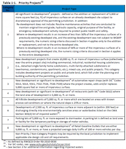
- All significant re-development1 projects – defined as the addition or replacement of 5,000 or more square feet (sq. ft) of impervious surface on an already developed site subject to discretionary approval of the permitting jurisdiction.
- New development projects that create 10,000 sq. ft. or more of impervious surface (collectively over the entire project site) including commercial, industrial, residential housing subdivisions (i.e., detached single family home subdivisions, multi-family attached subdivisions or townhomes, condominiums, apartments, etc.), mixed-use, and public projects. This category includes development projects on public and private land, which fall under the planning and building authority of the permitting jurisdiction.
- New development or significant re-development1 of automotive repair shops (with SIC Codes 5013, 5014, 5541, 7532-7534, 7536-7539) where the project creates, adds and/or replaces 5,000 square feet or more of impervious surface.
- New development or significant re-development1 of restaurants (with SIC Code 5812) where the land area of development is 5,000 sq. ft. or more.
- All hillside developments of 5,000 sq. ft. or more which are located on areas with known erosive soil conditions or where the natural slope is 25% or more.
- Developments of 2,500 sq. ft. of impervious surface or more adjacent to (within 200 feet) or discharging directly into environmentally sensitive areas or waterbodies listed on the CWA Section 303(d) list of impaired waters(3).
- Parking lots of 5,000 sq. ft. or more exposed to storm water. A parking lot is defined as land area or facility for the temporary parking or storage of motor vehicles.
- New development or significant re-development1 of Retail Gasoline Outlets that are either 5,000 sq. ft. or more, or have a projected average daily traffic of 100 or more vehicles per day.
Within the MS4 Phase 2 Permit Area/Mojave Watershed boundary the project categories that require a Preliminary WQMP are as follows:
- New development involving the creation of 5,000 ft2 or more of impervious surface collectively over the entire site.
- Significant re-development involving the addition or replacement of 5,000 ft2 or more of impervious surface on an already developed site.
- Road Project – any road, sidewalk, or bicycle lane project that creates greater than 5,000 square feet of contiguous impervious surface.
- LUPs – linear underground/overhead projects that has a discrete location with 5,000 sq. ft. or more new constructed impervious surface.
- Currently in the MS4 phase 2 area, single-family residence projects that create and/or replace 2,500 square feet or more of impervious surface and are not part of a larger plan of development are only required to implement Site Design. For further details, please refer to the PCMP template and guidance. This requirement may change with the adoption of future MS4 permits within this area. Please check your project/permit conditions prior to filling out a template
The difference between a Preliminary WQMP and a Final WQMP is the amount of detail to be filled out within the WQMP template. A Preliminary WQMP will include all of the content as a Final WQMP except for the operational procedures for maintenance of BMPs and a signed agreement. Essentially a Preliminary WQMP will be a 90% completed Final WQMP.
WQMP’s can only be completed by a licensed civil engineer. The engineer should communicate with all participants in the project to create the Best Management Practices possible.
Depending on what Watershed Region your project falls within will depend on which WQMP template you will use and which Technical Guidance Document (TGD) will be applicable. Both the Santa Ana & Mojave WQMP template as well as the Santa Ana’s Technical Guidance Document can be found on the County of San Bernardino, Department of Public Works – NPDES Section Website here.
The templates on the above website are subject to change, be sure to check the website for updates prior to filling out the template.
No recordation of maintenance responsibility is required as part of the plan.
The PCMP template and guidance can be found at (NPDES website link).
No special license is required to prepare the PCMP.
No special inspection is required. Therefore no additional inspection fees are required for a PCMP. The building inspector will verify that site plan design in the PCMP matches construction site during footing inspection.
PCMP needs to be approved prior to building permit issuance.
The current review fee for a PCMP can be found here County_Fee_Ordinance
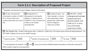
PCMP is required if the project falls within the MS4 phase 2 permit (Mojave) boundary AND is identifiable as one of the following types of projects:
- All non-residential projects greater than 2,500 square feet, but less than 5,000 square feet of impervious surface.
- All residential projects greater than 2,500 square feet of impervious surface including roof, driveway or porch, etc.
A PCMP only requires site features to be put in place to mitigate and reduce on-site pollutants while a WQMP requires site, source and treatment controls Best Management Practices to mitigate the impacts of the project.
A PCMP is utilized to reduce water pollutants by using proposed site features such as, but not limited to, landscaping, porous pavement and swales.
When the United States Government originally sold parcels of land they granted to the local agency (County of San Bernardino) patent reservations as a form of legal access for public use. For additional questions in regards to Patent Reservations you may access the BLM website http://www.glorecords.blm.gov/search/default.aspx or contact DPW Transportation Right of Way Division at 909 387-7940.
You can either check the BLM website http://www.glorecords.blm.gov/search/default.aspx or you can check the Schedule “B” located in your Title Report that will list every easement attached to your parcel.
Local and regional transportation fees are fees established by the County to pay for future road improvement projects within designated areas. Pursuant to Measure I 2010-2040, the State of California mandates that the County require new developments to pay their fair share contribution to future road improvement projects as a way to combat congestion within the County’s infrastructure.
See San Bernardino County Development Code Standards Chapter 83.05 Dedications and Installations of Street and Trail Improvements 83.05.020 Applicability.
Where there is no written agreement between the County and the private property owner there shall be a legal right by maintenance of roads by the County. This is called and Implied Dedication through maintenance and expenditure of public funds. See California Codes Civil Code Section 1006-1009 below or visit website:
https://leginfo.legislature.ca.gov/faces/codes_displaySection.xhtml?lawCode=CIV§ionNum=1009.
CALIFORNIA CODES CIVIL CODE SECTION 1006-1009
1009 (d) Where a governmental entity is using private lands by an expenditure of public funds on visible improvements on or across such lands or on the cleaning or maintenance related to the public use of such lands in such a manner so that the owner knows or should know that the public is making such use of his land, such use, including any public use reasonably related to the purposes of such improvement, in the absence of either express permission by the owner to continue such use or the taking by the owner of reasonable steps to enjoin, remove or prohibit such use, shall after five years ripen to confer upon the governmental entity a vested right to continue such use.
Yes… Under the Surface Mining and Reclamation Act of 1975 (“SMARA”, Public Resources Code, Section 2710 et seq.), counties and incorporated cities were given the responsibility (lead agency status) to issue a Mining Conditional Use Permit (CUP) and/or approve a Reclamation Plan for surface mining operations within their jurisdictions. San Bernardino County’s policies and ordinances regarding mining can be found in the 2007 General Plan and Division 8, Chapter 88.03 of the Development Code.
Yes… SMARA applies to both federal and non-federal lands where the local agency has adopted a surface mining ordinance. SMARA is not pre-empted by federal law because it regulates concerns not covered by federal law. The local lead agency under SMARA is required to consider both a mining permit and a reclamation plan for any new surface mine, and review the whole of this activity pursuant to California Environmental Quality Act (CEQA). Section 3809.3-1 of the Federal Land Policy and Management Act (FLPMA) recognizes the state’s responsibility in administering SMARA on federal land. In addition, both the Bureau of Land Management and the U.S. Forest Service have signed a Memorandum of Understanding (MOU) agreement with the California Department of Conservation and the State Mining and Geology Board for the implementation of SMARA on federal lands by local lead agencies. If your operation lies on federal land and exceeds the thresholds described below, you are required to obtain Reclamation Plan approval from the County before initiating operations.
SMARA established thresholds of one acre of surface disturbance and/or a surface excavation of 1,000 cubic yards. Mining operations that exceed either of these thresholds are required to obtain a Mining Conditional Use Permit and/or a Reclamation Plan approval from the County prior to initiating operations. For underground mines, these thresholds apply to any surface disturbance activities associated with the underground development including access to the mine, ore and overburden stockpiles and milling. You should be aware that SMARA has exempted certain types of mining operations. Please refer to SMARA Section 2714 and determine if your proposed activity is consistent with one of these exemptions.
In recognition of the fact that minerals are only found where they naturally occur, mining is permitted within most land use districts, subject to Planning Commission approval. Mining operations with accessory manufacturing processes may be limited if they occur in or within one-half mile of any residential land use district.
No… All mining projects undergo an environmental review per the requirements of CEQA at the onset of project application processing. The environmental review will evaluate the project’s potential environmental impacts and determine if an EIR is necessary. In most instances, a project’s environmental impacts can be mitigated below a level of significance, thereby avoiding the need to prepare an EIR. Surface mining operations that include a cyanide heap leach process, for the purpose of producing gold or other precious metals, automatically requires the preparation of an EIR.
A metallic mine is defined as one where more than ten percent of the mining operation’s gross annual revenues, averaged over the last five years, are derived from the production of metallic minerals. A complete list of metallic minerals is found in Section 3704.1(f) of the California Code of Regulations.
In some cases… SMARA Section 2773.3 prevents a lead agency from approving a reclamation plan for a surface mining operation to extract gold, silver, copper, or other metallic minerals unless the reclamation plan provides for the backfilling and contour grading of the mined lands to an elevation that utilizes all of the available material remaining at the completion of mining.
The mine operator, the County and the Department of Conservation must agree that reclamation is complete in accordance with the approved reclamation plan. Section 3805.5 of the California Code of Regulations describes, in greater detail, the responsibilities of a lead agency and the Department of Conservation with respect to the release of financial assurances and final closure.
Depending on available staffing, workload and other priorities, the process can be completed in three to nine months. In the event that an EIR is required, the review process can take up to a year or more.
In most cases… Revegetation is required during reclamation unless it is not consistent with the approved end use of the site. The vegetation used must be similar to the surrounding area and capable of self-regeneration without continued dependence on irrigation, soil amendments or fertilizer. Vegetation is important in stabilizing disturbed surfaces against the effects of long-term erosion. Evaluating test plots during mining is strongly encouraged and will help develop the best method that will ensure a successful plan to revegetate the entire site when mining is completed.
The County’s fee to process a mining application is based on the actual cost to review the project. The cost for a project is based on the time spent by staff to review the project, department overhead, coordination with State and Federal agencies and other expenses (i.e. copy costs, public hearings, additional permits) incurred during review of the project. An initial deposit is required as part of the application submittal and establishes a job account to which review expenses are charged against. The amount of the initial deposit may be determined by reviewing the first page of the County’s Mining and Land Reclamation Plan application.
Yes… SMARA requires that each operator provide financial assurances for reclamation of the entire operation in accordance with the approved Reclamation Plan. The assurance is to be in the amount that covers the County’s cost for reclaiming the mine site in the unlikely event that you are unable to complete reclamation. Financial assurances may be in the form of surety bonds, irrevocable letters of credit and certificates of deposit. The financial assurance is to be established and approved prior to initiating operations and is required to undergo a review by the County every year.
Yes… All operators are required to submit a Mining Operation Annual Report to the Department of Conservation and the County accompanied by the appropriate fee by July 1st each year pursuant to SMARA Section 2207. Mine operators must submit a copy of the entire annual report, including production information, to the State and the County. Please note that SMARA Section 2207(g) prohibits the release of production information to any member of the public. In addition, lead agencies are required to conduct an inspection of each surface mining operation annually. These inspections must be conducted by a qualified inspector experienced in land reclamation using the inspection form developed by the Department of Conservation and approved by the State Mining and Geology Board. SMARA allows lead agencies to collect reasonable fees to cover staff time and expenses to conduct the annual inspections.
Subject 1
Lorem ipsum dolor sit amet, consectetur adipiscing elit, sed do eiusmod tempor incididunt ut labore et dolore magna aliqua.
Lorem ipsum dolor sit amet, consectetur adipiscing elit, sed do eiusmod tempor incididunt ut labore et dolore magna aliqua.
Lorem ipsum dolor sit amet, consectetur adipiscing elit, sed do eiusmod tempor incididunt ut labore et dolore magna aliqua.
Lorem ipsum dolor sit amet, consectetur adipiscing elit, sed do eiusmod tempor incididunt ut labore et dolore magna aliqua.
Lorem ipsum dolor sit amet, consectetur adipiscing elit, sed do eiusmod tempor incididunt ut labore et dolore magna aliqua.
Subject 2
Lorem ipsum dolor sit amet, consectetur adipiscing elit, sed do eiusmod tempor incididunt ut labore et dolore magna aliqua.
Lorem ipsum dolor sit amet, consectetur adipiscing elit, sed do eiusmod tempor incididunt ut labore et dolore magna aliqua.
Lorem ipsum dolor sit amet, consectetur adipiscing elit, sed do eiusmod tempor incididunt ut labore et dolore magna aliqua.
Lorem ipsum dolor sit amet, consectetur adipiscing elit, sed do eiusmod tempor incididunt ut labore et dolore magna aliqua.
Lorem ipsum dolor sit amet, consectetur adipiscing elit, sed do eiusmod tempor incididunt ut labore et dolore magna aliqua.