Land Development Questions
Even if a road has been used for years, it does not necessarily mean that the public has the right to access it. A road will only be considered legal access if it has a dedicated right-of-way to the County, to the public in general, or an easement for public use. The road dedication requirement will establish the legal access necessary for the public to use the road.
When a project increases the vehicular traffic on a road within the County, in order to insure that there is no impact to public health and safety due to traffic or drainage issues, the County may require the applicant to pave the roadways affected by their project based on Development Code Section 83.05.
Submit a copy of the grant deed for the property to the Land Development Division in order to start the dedication process. Land Development will prepare a transmittal including the dedication requirements and will send the documents to the County Surveyors for preparation. Once the Surveyors have prepared the documents, they will mail them to the owner of the property for notarized signatures. Once signed, the owner will return to the Surveyors for recordation.
A dedication will take approximately 2 weeks to complete.
The County does not charge for a road dedication.
A road that is publicly dedicated does not necessarily get maintained by the County. The County will only maintain a road if the road is in the County Maintained Road System (CMRS). For information pertaining to the CMRS, contact the County Traffic Division at 909-387-8186
A road will only be considered legal access if it has a dedicated right-of-way to the County and to the public in general, or an easement for public/private use. In a case like this, if the road has been utilized uncontested for a minimum 5 years, prescriptive rights/easement may be established. See below for prescriptive rights.
If a road has been utilized uncontested for minimum of 5 years, prescriptive rights may be established. The evidence of use will be presented in a court of law, and a judge will rule on the establishment of the access rights.
Federal Emergency Management Agency- the operation of FEMA is to lead America to prepare for, prevent, respond to, and recover from disasters.
Flood zones are land areas identified by the Federal Emergency Management Agency (FEMA). Each flood zone describes that land area in terms of its risk of flooding. Everyone lives in a flood zone–it’s just a question of whether you live in a low, moderate, or high risk area.
Special Flood Hazard Area- the land area covered by the floodwaters of the base flood is the Special Flood Hazard Area on National Flood Insurance Program (NFIP) maps. The SFHA is the area where the NFIP’s floodplain management regulations must be enforced and the area where the mandatory purchase of flood insurance applies.
Within the County of San Bernardino you will find a total of six (6) flood zones, their designations and requirements within the County of San Bernardino are as follows:
Zone “A”
These are Special Flood Hazard Areas (SFHA) where flooding may be expected to occur at least once within a 100 (one-hundred) year period. All lenders must require borrowers to purchase and maintain flood insurance for Zone “A” properties.
A Project located within Flood Zone A will require the first floor to be elevated a minimum 2 feet above the natural highest adjacent ground in compliance with FEMA/SBC regulations. (Elevation Certificate is required.)
Zone “AE”
These are Special Flood Hazard Areas (SFHA) where flooding may be expected to occur at least once within a 100 (one-hundred) year period. Base Flood Elevations (BFEs) are shown. All lenders must require borrowers to purchase and maintain flood insurance for Zone “AE” properties.
A Project located within Flood Zone AE will require the first floor to be elevated a minimum 1 foot above the highest known base flood elevation (BFE) in compliance with FEMA/SBC regulations. (Elevation Certificate is required.)
Zone “AO”
These are Special Flood Hazard Areas (SFHA) subject to inundation by 1-percent-annual-chance shallow flooding (usually sheet flow on sloping terrain) where average depths are between one and three feet. Average flood depths derived from detailed hydraulic analyses are shown in this zone. All lenders must require borrowers to purchase and maintain flood insurance for Zone “AO” properties.
A project located within Flood Zone AO will require the first floor to be elevated a minimum 1 foot above the known shallow flooding depth in compliance with FEMA/SBC regulations. (Elevation Certificate is required.)
Zone “X” Shaded
These are areas where flooding is “anticipated” once in 500 (five-hundred) years or, if more frequently, only to minimal depths. Flood insurance is not mandatory in these areas, but is available.
A Project located within Flood Zone X Shaded will require the first floor to be elevated a minimum 1 foot above the natural highest adjacent ground in compliance with SBC regulations.
Zone “X” Unshaded
This is the most desirable area, and requires no insurance.
There are no elevation requirements within this flood zone.
Zone “D”
These are areas which have not been studied and therefore requirements vary pending the scope, area and engineering for the project.
Special note: Floodways may be present, within zones A and AE, and are extremely hazardous areas- No Construction is permitted without the submission of a Hec-Ras analysis, prepared by a registered civil engineer,showing pre development and post development. Post development shall have no rise in water surface elevation. For more information on zones and requirements please see the Development Code section 82.14 or the FEMA website.
You can look up your flood zone on the FIRMette (Flood Insurance Rate Map) website located at https://msc.fema.gov/portal it is the most up-to- date information. The maps they provide not only allow you to view your property, but will also allow you to print out a copy so that you may present to your lender or insurance agent if you are ever asked.
Everyone lives in a flood zone. The fact that a flood hasn’t occurred within recorded history does not mean one hasn’t happened in the past or that one will not happen in the future.
It’s important to note that flood history is only one element used in determining flood risk. More critical determinations are made by evaluating your community’s rainfall and river flow data, topography, wind velocity, tidal surge, flood control measures, building development (existing and planned) and community maps.
Floods can occur in any area, although to varying degrees. If you live on a hill or in an area that has never been flooded, your risk may be significantly reduced, but it is not eliminated.
Flooding can be caused by heavy rains, melting snow, inadequate drainage systems, failed protective devices such as levees and dams, as well as by tropical storms and hurricanes. Please make an informed decision about the flood risks you face before deciding not to purchase flood insurance. Talk to your agent for additional details – you may qualify for a Preferred Risk Policy (a lower-cost flood insurance policy).
Yes. If you believe that the FIRM designation is erroneous you may submit an engineering study to FEMA and request a LOMA (letter of map amendment). If based on the study you provide, FEMA agrees that your property is not located in a special flood hazard area, a LOMA will be issued, and you may no longer be required to purchase or maintain flood insurance (some lenders may still require it).
An elevation certificate is a document that certifies details about the elevation of a potential future or existing structure as it relates to the elevation of the projected 100 year flood plain. New buildings and substantial improvements in all identified SFHAs (flood zones A, AE & AO) are required to have an elevation certificate.
The elevation information must be submitted on the Elevation Certificate in effect at the time that the Elevation Certificate was completed and signed. Elevation Certificates can only be completed by a licensed land surveyor, engineer, or architect who is licensed by the State to perform such functions.
The Elevation Certificate is an important administrative tool of the NFIP. It is to be used to provide elevation information necessary to ensure compliance with community floodplain management ordinances, to determine the proper insurance premium rate, and to support a request for a LOMA or LOMR-F. The Elevation Certificate is required in order to properly rate Post-FIRM (after 09/29/1978) buildings, which are buildings constructed after publication of the FIRM located in Flood Zones. The Elevation Certificate is not required for Pre-FIRM (before 09/29/1978) buildings unless the building is being rated under the optional Post-FIRM (after 09/29/1978) flood insurance rules. Use of this certificate does not provide a waiver of the flood insurance purchase requirement.
An elevation certificate should be on the record permit within the building and safety division for properties within a SFHA. Please contact the Land Use Services Building and Safety Division to request a copy.
If a copy of the elevation certificate cannot be found on the record permit, then more than likely your structures was built Pre-FIRM (before 09/29/1978) and no elevation certificate was required at that time. If your structure was built Post-FIRM (after 09/29/1978) and the elevation certificate cannot be found on the record permit, you will need to contact a land surveyor or engineer licensed by the state, to perform such functions, and create one. For flood insurance purpose only, the owner can fill out the Elevation Certificate for the existing house without the requirement of Engineer nor Land surveyor. Instructions on how to fill out an elevation certificate can be found by clicking here
There are a number of different possible answers to this question:
- The previous owner could have purchased the land without having a lender involved. Only lenders are required to enforce participation in the National Flood Insurance Program; there is no public law requiring such participation. Therefore, people who purchase flood insurance do so either for their own protection or due to the requirement of their mortgage holder.
- The property may have been purchased before the flood maps and requirements concerning flood insurance were either in place or being enforced.
- The flood maps in a given area may have been recently revised. This works both ways in that area which were previously not located in a special hazard area may now be, or better yet, areas that had been categorized in a hazard zone may now be clear.
A WQMP is a special engineering study that identifies the potential impacts to our local creeks caused by a projects post-construction water runoff. A WQMP identifies all project related pollutants, impacts to the sites hydrologic condition and proposes Best Management Practices (BMPs) to mitigate the effects of the development.
A Water Quality Management Plan is required if the project falls with the MS4 Phase 1 permit (Santa Ana) boundary as well as the proposed MS4 Phase 2 permit (Mojave) boundary AND is identifiable as one of the following types of projects:
Within the MS4 Phase 1 Permit Area/Santa Ana Watershed boundary the project types that require WQMP’s are as follows:
Within the MS4 Phase 2 Permit Area/Mojave Watershed boundary the project types that require WQMP’s are as follows:
Currently in the MS4 phase 2 area, single-family residence projects that create and/or replace 2,500 square feet or more of impervious surface and are not part of a larger plan of development are only required to implement Site Design. For further details, please refer to the PCMP template and guidance. This requirement may change with the adoption of future MS4 permits within this area. Please check your project/permit conditions prior to filling out a template
A Preliminary WQMP is required to ensure compliance with all jurisdictional requirements applicable to the development project. A Preliminary WQMP is required when a project falls within the jurisdictional boundaries of the MS4 Phase I & proposed MS4 Phase II boundaries AND falls under any of the below categories within their respective boundaries.
Within the MS4 Phase 1 Permit Area/Santa Ana Watershed boundary the project categories that require a Preliminary WQMP are as follows:
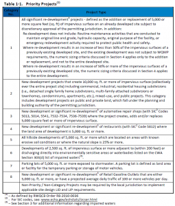
- All significant re-development1 projects – defined as the addition or replacement of 5,000 or more square feet (sq. ft) of impervious surface on an already developed site subject to discretionary approval of the permitting jurisdiction.
- New development projects that create 10,000 sq. ft. or more of impervious surface (collectively over the entire project site) including commercial, industrial, residential housing subdivisions (i.e., detached single family home subdivisions, multi-family attached subdivisions or townhomes, condominiums, apartments, etc.), mixed-use, and public projects. This category includes development projects on public and private land, which fall under the planning and building authority of the permitting jurisdiction.
- New development or significant re-development1 of automotive repair shops (with SIC Codes 5013, 5014, 5541, 7532-7534, 7536-7539) where the project creates, adds and/or replaces 5,000 square feet or more of impervious surface.
- New development or significant re-development1 of restaurants (with SIC Code 5812) where the land area of development is 5,000 sq. ft. or more.
- All hillside developments of 5,000 sq. ft. or more which are located on areas with known erosive soil conditions or where the natural slope is 25% or more.
- Developments of 2,500 sq. ft. of impervious surface or more adjacent to (within 200 feet) or discharging directly into environmentally sensitive areas or waterbodies listed on the CWA Section 303(d) list of impaired waters(3).
- Parking lots of 5,000 sq. ft. or more exposed to storm water. A parking lot is defined as land area or facility for the temporary parking or storage of motor vehicles.
- New development or significant re-development1 of Retail Gasoline Outlets that are either 5,000 sq. ft. or more, or have a projected average daily traffic of 100 or more vehicles per day.
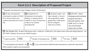
Within the MS4 Phase 2 Permit Area/Mojave Watershed boundary the project categories that require a Preliminary WQMP are as follows:
- New development involving the creation of 5,000 ft2 or more of impervious surface collectively over the entire site.
- Significant re-development involving the addition or replacement of 5,000 ft2 or more of impervious surface on an already developed site.
- Road Project – any road, sidewalk, or bicycle lane project that creates greater than 5,000 square feet of contiguous impervious surface.
- LUPs – linear underground/overhead projects that has a discrete location with 5,000 sq. ft. or more new constructed impervious surface.
- Currently in the MS4 phase 2 area, single-family residence projects that create and/or replace 2,500 square feet or more of impervious surface and are not part of a larger plan of development are only required to implement Site Design. For further details, please refer to the PCMP template and guidance. This requirement may change with the adoption of future MS4 permits within this area. Please check your project/permit conditions prior to filling out a template
The difference between a Preliminary WQMP and a Final WQMP is the amount of detail to be filled out within the WQMP template. A Preliminary WQMP will include all of the content as a Final WQMP except for the operational procedures for maintenance of BMPs and a signed agreement. Essentially a Preliminary WQMP will be a 90% completed Final WQMP.
Depending on what Watershed Region your project falls within will depend on which WQMP template you will use and which Technical Guidance Document (TGD) will be applicable. Both the Santa Ana & Mojave WQMP template as well as the Santa Ana’s Technical Guidance Document can be found on the County of San Bernardino, Department of Public Works – NPDES Section Website here.
The templates on the above website are subject to change, be sure to check the website for updates prior to filling out the template.
WQMP’s can only be completed by a licensed civil engineer. The engineer should communicate with all participants in the project to create the Best Management Practices possible.
A PCMP is utilized to reduce water pollutants by using proposed site features such as, but not limited to, landscaping, porous pavement and swales.
A PCMP only requires site features to be put in place to mitigate and reduce on-site pollutants while a WQMP requires site, source and treatment controls Best Management Practices to mitigate the impacts of the project.
PCMP is required if the project falls within the MS4 phase 2 permit (Mojave) boundary AND is identifiable as one of the following types of projects:
- All non-residential projects greater than 2,500 square feet, but less than 5,000 square feet of impervious surface.
- All residential projects greater than 2,500 square feet of impervious surface including roof, driveway or porch, etc.
The current review fee for a PCMP can be found here County_Fee_Ordinance
PCMP needs to be approved prior to building permit issuance.
No special inspection is required. Therefore no additional inspection fees are required for a PCMP. The building inspector will verify that site plan design in the PCMP matches construction site during footing inspection.
No special license is required to prepare the PCMP.
The PCMP template and guidance can be found at (NPDES website link).
No recordation of maintenance responsibility is required as part of the plan.
When the United States Government originally sold parcels of land they granted to the local agency (County of San Bernardino) patent reservations as a form of legal access for public use. For additional questions in regards to Patent Reservations you may access the BLM website http://www.glorecords.blm.gov/search/default.aspx or contact DPW Transportation Right of Way Division at 909 387-7940.
You can either check the BLM website http://www.glorecords.blm.gov/search/default.aspx or you can check the Schedule “B” located in your Title Report that will list every easement attached to your parcel.
Local and regional transportation fees are fees established by the County to pay for future road improvement projects within designated areas. Pursuant to Measure I 2010-2040, the State of California mandates that the County require new developments to pay their fair share contribution to future road improvement projects as a way to combat congestion within the County’s infrastructure.
See San Bernardino County Development Code Standards Chapter 83.05 Dedications and Installations of Street and Trail Improvements 83.05.020 Applicability.
Where there is no written agreement between the County and the private property owner there shall be a legal right by maintenance of roads by the County. This is called and Implied Dedication through maintenance and expenditure of public funds. See California Codes Civil Code Section 1006-1009 below or visit website:
https://leginfo.legislature.ca.gov/faces/codes_displaySection.xhtml?lawCode=CIV§ionNum=1009.
CALIFORNIA CODES CIVIL CODE SECTION 1006-1009
1009 (d) Where a governmental entity is using private lands by an expenditure of public funds on visible improvements on or across such lands or on the cleaning or maintenance related to the public use of such lands in such a manner so that the owner knows or should know that the public is making such use of his land, such use, including any public use reasonably related to the purposes of such improvement, in the absence of either express permission by the owner to continue such use or the taking by the owner of reasonable steps to enjoin, remove or prohibit such use, shall after five years ripen to confer upon the governmental entity a vested right to continue such use.